Confirmed This Week: Earth Has a “Second Moon”

Share this
Share

About Earth’s New Little Moon

After putting in its time, an asteroid called “Asteroid 2016 HO3” has now been confirmed by NASA to be a permanent resident in the Earth’s gravitational field.

The asteroid was discovered earlier this year by University of Hawaii’s Institute for Astronomy, but it has been a “stable quasi-satellite” for almost 100 years.

Asteroid 2016 HO3 is between 120 and 300 feet in diameter (40-100 meters). The asteroid poses no threat of hitting the Earth, and will never come closer than 14 million kilometers (9 million miles) from our planet.

(For point of comparison, the average distance to the moon is less than 400,000 km.

Asteroid 2016 HO3 orbits the Earth somewhat similarly to our regular moon, but in an uneven pattern in which the rock drifts ahead of the Earth for a couple years as both orbit the sun, before the Earth’s gravity pulls the rock back and it falls behind the Earth for a few years. The relationship between the Earth and the asteroid has been likened to a dance.

Image: Paul Chodas, NASA and the Jet Propulsion Laboratory

Curiosity Rover Reaches Mars’s Sand Dunes — Photos

NASA
Share this
Share

The active sand dunes of Mars were reached by NASA’s Curiosity rover last month, and Friday NASA released some of Curiosity’s latest photography.

The Bagnold Dunes are as high as two stories, and compose the bottom portion of a layered mountain Curiosity is trekking up this month.

Some of Curiosity’s latest photos show the bot’s view looking up the dune hill. Others show the texture of the sand its treaded wheels are covering.

NASA states that the individual dunes of the Bagnold band — which is located along the northwestern flank of Mount Sharp inside Gale Glacier — move up to 3 feet (1 meter) per year, based on observations from orbit.

Curiosity’s current mission task is to scale Sharp and examine the higher layers. It has already explored outcrops between its landing site and the mountain since landing in August 2012.

By James Haleavy

Photos: NASA

NASA Developing Mission To Capture Boulder From Asteroid, Send It Into Moon Orbit

NASA
Share this
Share

First-of-its-kind NASA mission will also demonstrate ability to deflect asteroids

NASA has detailed ARM: its mission to send a robotic spacecraft to an asteroid, pluck a boulder off of the surface, and put the rock into orbit around the moon. It will also use an Enhanced Gravity Tractor to redirect the course of the asteroid.

The Asteroid Redirect Mission (ARM) includes other important stages as well: after capture from the yet-undecided upon asteroid, astronauts will shuttle out to the robot in NASA’s Orion craft to study the surface and bring samples back.

Two technological goals were clearly stated by NASA in relation to ARM: The mission will demonstrate NASA’s ability to deflect an object in space that threatens the planet, and it will test capabilities that will be required for the first crewed mission to Mars.

The course of the mission is planned as follows: the robotic spacecraft would fly by the asteroid several times, optically scanning the surface. It would then land above the boulder targeted. It would attach arms to the surface of the boulder, then push off again from the asteroid. The robotic craft would analyze the boulder for three days.

The next stage would be demonstration of NASA’s ability to redirect an asteroid using what it calls an Enhanced Gravity Tractor (EGT): The robotic craft would measure, calibrate and use the gravitational attraction between the asteroid and itself to alter the course of the asteroid, sending it in a chosen direction.

Then the robotic craft will set off for the lunar orbit, making use of its time with the boulder by scanning it further. The rock will be sent into a stable orbit around the moon.

Astronauts will rocket out to the boulder in NASA’s Orion spacecraft, secure Orion to it, and the astronauts will take space walks to study and collect samples, leaving the rock in orbit around the moon when they return to Earth.

NASA plans to launch the ARM robotic spacecraft at the close of the decade.

By Andy Stern
Source: NASA

NASA Puzzled By 8,000 Year Old Earthworks In Kazakhstan

NASA
Share this
Share

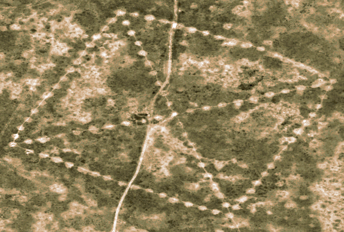
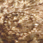
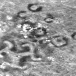
NASA Satellite imagery of a barren and treeless steppe in northern Kazakhstan has revealed enormous earthworks that can only be seen from the air. Some of the formations date back 8000 years and are thought to have been built by the neolithic groups of the area.

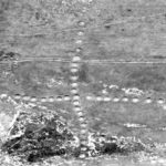
Known as the Steppe Geoglyphs, these formations are as large as several football fields. The largest structure consists of 101 raised mounds, each 3 feet high and 30 feet across, creating a square with an X or cross intersecting it. There are at least 260 mounds, trenches, and ramparts in 5 different shapes found across the steppe.

The mounds were first discovered on Google Earth by a Kazakh economist and archaeology enthusiast Dimitry Dey in 2007. Since then, the Steppe Glyphs had gained little public attention until they were shown last year at an archaeology conference in Istanbul in which they were described as “unique” and “unstudied.”

The geoglyphs remained unstudied and virtually unknown until two weeks ago when NASA released high-definition satellite images, sparking public and archaeological interest. Archaeologists are trying to figure out what the importance of such massive arrays were to the neolithic people who created them, and why they can only be seen from above. Such a feat defies our current understanding of the capabilities of neolithic peoples to organize, build, and communicate.

“The idea that foragers could amass the numbers of people necessary to undertake large-scale projects — like creating the Kazakhstan geoglyphs — has caused archaeologists to deeply rethink the nature and timing of sophisticated large-scale human organization as one that predates settled and civilized societies,” Persis B. Clarkson, an archaeologist at the University of Winnipeg told the New York Times.

Archaeologists are hopeful that the Steppe Glyphs will provide further insight into just how the stone-age tribes functioned, and what kind of knowledge they had acquired. Many theories have been posed about the reason behind the glyphs, including aliens, relations to Hitler (even though the Swastika was used much earlier than the 20th century), and constellation mapping. Theories of the glyphs’ purpose range from the ridiculous to the entirely possible.

In March of 2007, Mr. Dey, 44, was at home watching “Pyramids, Mummies, and Tombs” on The Discovery Channel. “There are pyramids all over the Earth,” he remembered thinking. “In Kazakhstan there should be pyramids too.” Mr. Dey then searched through the landscape of Kazakhstan on Google Earth, and instead came across what he thought were old Soviet installations until finding more than 15 different formations.

Kazakhstan has also called for urgent protection by UNESCO as an important cultural heritage site — so far without reply. Earlier this year a formation called The Koga Cross was destroyed by road builders, even after Mr. Dey notified officials.

Tony Simpson